Geofencing gets implemented in regional ride-hailing platforms with the same logic applied to any other configuration panel feature: because it is available and because large platforms use it. The problem with that logic is that a geofence is not a product feature — it is a geographic boundary that triggers a specific operational event. That event can be a fare change, a service restriction, a driver incentive, or a passenger notification. Its value depends entirely on whether the event it triggers corresponds to a real problem occurring in that specific zone. When it does, geofencing produces measurable results: lower cancellation rates in zones with atypical behavior, better driver distribution across high-demand corridors, and margin protection at high-wait-time pickup points. When it doesn't, it produces active zones that no one reviews, geographic boundaries that passengers don't understand, and maintenance overhead for an operations team with more pressing priorities.
This article is for operators with 200 to 600 daily trips evaluating whether to implement geographic zones on their platform, or who already have active zones and don't know for certain whether they are producing the expected effect. The analysis is organized around three practical questions: which specific use cases justify building a geofence, when dynamic route recalculation or flat fares by trip type solve the same problem with less technical complexity, and how to evaluate whether an active zone is doing its job or simply occupying space in the configuration panel.
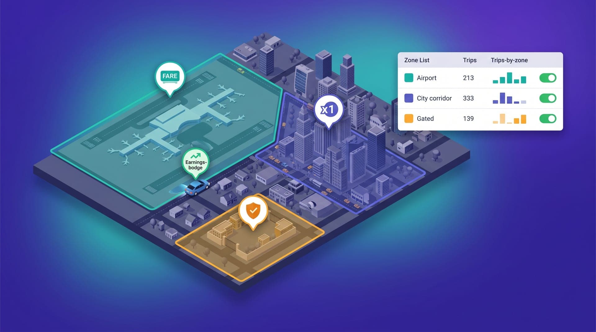
The three geofencing uses that produce returns in mid-size operations
Not all possible uses of geofencing produce operational returns proportional to the implementation and maintenance effort. In operations of 200 to 600 daily trips in secondary LATAM markets, three use cases recur frequently enough to justify building and actively managing a zone. The first is the airport: the pickup area of an airport has atypical behavior that standard fare rules don't address well. Drivers wait 8 to 20 minutes to locate the passenger in the arrivals area, a time that on short city-center trips makes the ride unprofitable for the driver and produces cancellations just before the trip starts. A guaranteed minimum fare inside the airport zone — between 1.5 and 2.5 times the base fare for the minimum distance — eliminates that negative calculation without changing the pricing policy for the rest of the platform.
The three uses that consistently produce operational returns in mid-size operations are:
- Airport zone with guaranteed minimum fare: protects the driver from the cost of wait time at a point where terminal access can delay trip start by 10 to 25 minutes, and protects the platform from committing to ETAs it cannot honor due to arrivals-area access restrictions
- Differential incentive zone in corridors with systematically high demand: an earnings multiplier for drivers available in a specific zone during the time windows where demand consistently exceeds supply — hotels, business districts, hospitals with regular shift start and end times
- Service restriction zone for drivers with incomplete documentation: restricts trips from or to areas with specific regulatory exposure — shopping centers with their own taxi concession, zones with frequent permit inspection operations — to drivers with current insurance and updated permits
The boundary effect: why zone edges create more problems than they solve
The most common operational problem with poorly designed zones is not at the center of the zone but at its boundary. A passenger 200 meters outside a differential-fare zone sees the standard price; a passenger 200 meters inside sees a different one. In dense urban areas of a mid-size LATAM city, those 200 meters can be two blocks in the same neighborhood, with passengers perceiving differential treatment without understanding why. The effect is amplified when the zone is visible on the app map: the passenger who is outside and sees that trips originating inside carry a different fare tries to shift their pickup point inward, generating manually adjusted pickup requests that don't correspond to their actual location. That produces trips with an undeclared initial walking leg, longer actual pickup times, and drivers who arrive at a corner with no one waiting.
Zone boundary design is a technical problem with direct operational consequences. Zones with straight edges that cut streets in the middle — instead of following neighborhood logic or a main avenue's alignment — generate the worst boundary effects because they don't correspond to any geographic reality the passenger recognizes. The most effective zones follow natural boundaries: a main avenue, the airport perimeter, the declared access points of a residential development. When the boundary makes geographic sense to the passenger, the price difference is perceived as a justified service difference — 'it is airport pricing' — rather than an arbitrary system inconsistency that support will have to explain.
When dynamic routing solves the problem without a fixed zone
Geofencing is the right solution for stable, recurring problems that occur in predictable geographic zones. It is not the right solution for variable problems that change in location, time, or frequency. A street closure from construction, a temporary detour around an event, the opening of a new commercial development that generates demand at a point the operation doesn't yet cover well — these are dynamic routing problems, not fixed-zone problems. Solving a transient demand problem with a geofence produces a zone the team must manually remove when the problem disappears, and if forgotten, one that activates differential fare logic or an incentive in a zone where it no longer applies. That is the origin of most active zones that no operator can explain why they exist.
Pricing based on real-time distance and time — fare calculated from the actual route the driver travels at the moment of the trip — automatically solves the problems that origin-zone fare geofencing tries to solve manually. In an operation where the passenger inputs a destination address before the driver arrives, real-distance pricing is more accurate than any fixed-fare zone because it incorporates traffic, the actual route traveled, and the conditions of the moment. Fixed-fare geofences make sense primarily for predictable point-to-point trips — airport to downtown, stadium to hotel — where the operator wants a closed price the passenger sees before confirming, not an estimate that varies depending on which route the driver chooses.
Driver positioning by zone: the most underrated use
The geofencing use that generates the most return in mid-size operations — and that the fewest operators implement deliberately — is driver positioning. The logic is straightforward: the platform has demand data the individual driver doesn't have. It knows the central hospital has a shift change at 14:00, that the airport has two commercial flights landing between 16:30 and 17:15, that the north corridor office zone generates 60 to 80 requests in the first 20 minutes after 18:00. The driver doesn't need all that information — they need to know whether being in a specific zone during a specific window will generate more trips than staying in their usual position. The positioning geofence solves exactly that: it activates an additional incentive for drivers inside the zone during the defined time window, independently of whether they have already received a trip.
The difference between a positioning zone incentive and a trip-volume bonus is that the former solves the problem before demand occurs — it concentrates supply in the right place at the right time — while the latter retroactively rewards the driver who happened to already be in the right place. In an operation with 40 to 80 simultaneously active drivers, the difference between having 12 drivers in the right corridor at 18:00 versus having 5 distributed randomly can be the difference between a 4-minute and a 9-minute wait time for passengers in that window. In the first weeks of a new market, those 5 minutes determine whether passengers become recurring users or dismiss the platform before giving it a second chance.
Maintaining active zones: the cost that doesn't appear in the budget
Every active zone on a ride-hailing platform is a standing operational commitment. The airport minimum-fare geofence built when the airport had a single terminal stays active when a second terminal opens 800 meters away, outside the original boundary. The incentive zone created for a four-day event that ended last month keeps activating bonuses for drivers who pass through that area. The restriction zone configured for a corridor where permit inspection operations no longer occur keeps excluding drivers who could serve real demand. Platforms with more than ten active zones and no periodic review process accumulate obsolete operational logic that the team doesn't remember why it exists and that no one dares to remove for fear of breaking something that once worked.
The minimum governance process for an active zone portfolio has two components. The first is zone ownership: each geofence needs a name that includes the reason for its existence ('airport-minimum-fare', 'central-hospital-late-shift') and a member of the operations team responsible for its review. The second is a monthly activity review: the responsible person confirms that the trip or driver volume activating each zone is still as expected, and that the metric the zone was supposed to improve is still better than before activation. A zone with zero activations in the last month is an immediate deletion candidate. A zone with activations but without the expected impact on the metric that justified its creation — wait time, cancellation rate, driver density in the target time window — needs adjustment or removal before the team forgets what it was built for.
We had 17 active zones when I did the first serious inventory. Three were from the original launch 14 months earlier and no one remembered why we had created them. Four were from specific events that had already ended. When I reviewed them one by one, I found that nine were producing the correct effect, four needed boundary adjustments, and four had no measurable impact on the metrics they were supposedly improving. Removing those four and adjusting the other four reduced driver complaints about unexpected incentive activations by 60% in the following month. The problem was not the zones themselves — it was that no one had reviewed them after creating them.
Which geofences to build first if you are starting from scratch
An operator configuring zones for the first time must answer three questions before drawing the first boundary: which specific operational problem they are trying to solve, in which specific geographic zone that problem occurs frequently enough to justify a permanent solution, and how they will measure whether the zone is producing the expected effect. Without those three answers, the geofence is a bet — it may work or may generate side effects the operator didn't anticipate. With those three answers, the geofence is a hypothesis that can be confirmed or refuted in the first two weeks of activation, using real data.
The implementation order that produces the highest return with the lowest operational risk on a new platform is:
- First — airport zone with minimum fare, if the city has active commercial flights: this is the geofence with the clearest business case and lowest boundary-effect risk because the airport has a recognizable perimeter for the passenger and a predictable demand pattern that justifies the differential logic
- Second — positioning zone at the operation's most predictable high-demand point: the hospital with regular shifts, the shopping center with a fixed closing time, the stadium on game days — configured to activate only during the time window where demand systematically exceeds supply, with an incentive for being available inside the zone during that window
- Third — service restriction zone if there is a specific point where the regulatory requirement differs from the rest of the city: this case is less common but has direct operational consequences if omitted in cities with frequent permit inspection operations
- Never before having data — do not build general differential-fare zones ('city center zone', 'north zone') without at least four weeks of demand data confirming a recurring pattern: preventive geofences that don't respond to a documented problem are the origin of the zones no one remembers why they exist
Geofencing is not a platform feature you activate to match the sophistication of large operations — it is a tool for solving specific operational problems that occur in specific geographic zones with enough regularity to justify a permanent solution. An operator with three well-designed zones, boundaries that passengers understand, success metrics defined before activation, and a monthly review process has a real operational advantage over an operator with seventeen active zones that no one has reviewed since they were created. The number of zones is not an indicator of sophistication — the precision with which each zone answers the operational question that justified its existence is.
The test for any active geofence is simple: did the metric the zone was supposed to improve change in the expected direction after activation, and is it still moving in that direction today? If the answer is yes, the zone earns its right to stay active. If the answer is no or 'I don't know because we never measured it,' the zone is a candidate for immediate review. Operations that grow from 300 to 600 daily trips without accumulating unnecessary configuration complexity do so because the team managing zones applies the same rigor they apply to any other operational process: measure before building, review after activating, remove what isn't working before it becomes part of the landscape that no one understands but everyone is afraid to touch.